Showing posts with label Brendon Hills. Show all posts

Sunday, 17 January 2021

A view from the Blackdown Hills of the Somerset town of Wellington.

On an early autumn day a couple of years ago I was driving along the northern ridge of the Blackdown Hills when I came upon a car park, above Quarts Moor, a short distance east of the Wellington Monument.  The car park allows a fine view of the town of Wellington and the Wellington Monument to the west.

I, of course, parked up and took some photos.  In the picture below two buildings are prominent.  On the left is the red brick factory building of Tonedale Mills and on the right is the Church of St. John the Baptist.  In the background are the Brendon Hills on the left and the Quantock Hills on the right.

A view of the Somerset town of Wellington taken from the Blackdown Hills.

Tonedale Mills was owned by Fox Brothers, a family firm originating from 1796.  Clothmaking and the dyeing of wool was carried out at the factory which was rebuilt in brick after the original burned down in 1821.

Of St. John the Baptist Pevsner tells us: “The best part of the church is its red sandstone tower of good ashlar.  Tall, sturdy, and with the stair-turret rising high and placed in the Totnes position – i.e. in the middle of the south side.”

I will take the liberty of following the marvellous example of Michael Portillo and quote what Bradshaw’s Handbook of 1863 had to say about Wellington.

Here is a Gothic church of which W. S. Salkeld was rector in James I’s time.  The Duke of Wellington, who derives his title from this place, is lord of the manor.  A pillar, in honour of The Hero of Waterloo, was erected on Blackdown Hill.  This range of hills is on the Devonshire borders, and produces stone used by scythe grinders &c. 

Quitting the station, and again crossing the Tone, we enter an excavation which conducts us to the White Ball Tunnel, a fine piece of arched brickwork nearly one mile in length.  About the centre we attain the highest elevation between Bristol and Exeter, and on emerging from its obscuration we find ourselves in the magnificent county of Devon, with the Wellington memorial cresting the summit of a distant hill on our left, and the long range of precipices, known as the Blackdown Hills, far away before us, apparently extending to the very verge of the sea.

Bradshaw also informs us that the population of Wellington is 3,689.  I very much doubt he could have imagined its population today would be approaching 15,000!

Saturday, 24 October 2020

A visit to the village of Wambrook in South Somerset, and its Church of St. Mary.

The village of Wambrook is tucked away in the Blackdown Hills 2 miles southwest of the town of Chard in South Somerset.  To find the village you have to explore the narrow tree-lined country lanes off the A30 – the main road which climbs steadily out of Chard into the foothills of the Blackdowns.

My wife and I, after visiting The Barleymow Farm Shop on the A30, took several wrong turns before finding the village.  It seemed to consist of scattered homes straggling along an undulating country lane, and we could find nowhere convenient to stop until we came to its Church of St. Mary.

The Church of St. Mary in the South Somerset village of Wambrook.

Arthur Mee in his The King’s England, Somerset (Hodder and Stoughton Ltd., 1968) informs us that: “In 1896 this village was transferred from Dorset to Somerset.  The little medieval church has rounded doorways and a font of the thirteenth century, bench ends carved 400 years ago, an Elizabethan chalice engraved with its price of 35 shillings, and a gallery at the back for the ringers of three ancient bells.”  However, the Wambrook parish church website states there are 5 bells in the tower!  The Church is built of Ham stone rubble and ashlar dressing, and it is thought the original roof was thatched.*  

On entering the churchyard the first thing which caught our eye was the seventeenth century set of stocks beside the wall of the church.  We followed the footpath through the churchyard and into a field.  We didn’t venture further as the going become steeper, but we could look down toward a brook and across the wooded valley. On the opposite side of the wooded valley we could see a large building which we later discovered to be the Cotley Inn.

Seventeenth century stocks beside the Church of St. Mary in Wambrook, South Somerset.

Retracing our steps through the churchyard we noticed the Commonwealth War Grave of Private W. J. Larcombe who was serving in the Royal Army Veterinary Corps when he died on 10 July 1944 aged 24.  He was the son of Charles Victor and Emily Caroline Larcombe, and husband of Louisa Elizabeth Larcombe of Islington, London.

Nearby was another headstone, that of Walter George Pidgeon. The headstone also commemorated the passing of “our dear boys”.  One of them, Sidney John Pidgeon, died at the early age of 16.  The other, Walter Frank Pidgeon, died of wounds on 24 February 1945 in Myanmar (formerly Burma) while serving as a private in the Second Battalion, King’s Own Scottish Borderers.  It seems he may have been wounded when the KOSB took part in the successful assault on Japanese positions on the Irrawaddy line in early 1945.  He is at rest in the Commonwealth War Graves Commission’s Tuakkyan  War Cemetery in Myanmar. His wife, Viola Beatrice Rosalind Pidgeon was from Chard, Somerset.

Gravestone commemorating members of the Pidgeon family in the Church of St. Mary in Wambrook, South Somerset.

The tower of St. Mary's Church in the village of Wambrook, South Somerset.

We returned to the car and drove on into the valley and up the other side past the Cotley Inn.  After more twists and turns we reached the top of the hill where there was a fine view toward Chard.  We carried on down the other side enjoying the scenery and eventually re-joined the A30.  I hope to go back with my camera to the hill above the Cotley Inn and take some landscape pictures of the Somerset countryside south of Chard.

*https://wambrookparishchurch.com/history.html

Sunday, 19 May 2019

The Parish Church of St. Andrew in the village of Old Cleeve, West Somerset, and its noble view across Blue Anchor Bay.


Last Monday, as it was such a fine sunny day, my wife and I decided to visit the village of Dunster in West Somerset.  I drove across the beautiful Blackdown Hills to Taunton and then up the A358 between the delightful Quantocks and Brendons.   Once on the A39 we headed for Dunster, but after passing through Washford we decided to take a short detour along the narrow lanes to the village of Old Cleeve.

I had read of a famous epitaph on the gravestone of the local blacksmith, George Jones, who died in 1808, and wanted to see if I could find it in the graveyard at Old Cleeve’s Parish Church of St. Andrew.

Arthur Mee, in his The King’s England, Somerset (Hodder and Stoughton, 1968), writing of Old Cleeve states that: “It has a noble outlook, through the trees across the wide bay to where North Hill rises like a mountain from the sea.  Raised above the cottage roofs, the church has the best of the view, for which it took its seat 500 years ago.”
The Parish Church of St. Andrew in the village of Old Cleeve, West Somerset.
The view toward North Hill across Blue Anchor Bay from the churchyard of the Parish Church of St. Andrew in Old Cleeve, West Somerset.

I found the Church of St. Andrew on the hillside above the village and took some photos of the view across Blue Anchor Bay noted by Arthur Mee, but I could not find the grave of George Jones.  However, I discovered the blacksmith’s epitaph in Edward Hutton’s Highways and Byways in Somerset, (Macmillan and Co. Ltd., 1923), and reproduce it verbatim below:

My Sledge and Hammer lie reclined,

My Billows too have lost their wind;

My Fire’s extinct, my Forge decay’d,

And in the Dust my Body’s laid;

My Coal is burnt, my Iron’s gone,

My Nails are drove, my Work is done.


Saturday, 7 April 2018

The Ancient Mariner and Yankee Jack on The Esplanade overlooking Watchet Marina on the Somerset Coast.


It was a pleasant April day – pleasant days have been a rarity so far this year – so my wife and I decided on an afternoon drive up the A358 toward Watchet on the coast of Somerset.  The road was not very busy at all so it was an enjoyable saunter to Williton viewing the Quantock Hills to our right and the Brendon Hills to our left.

In Watchet we left the car in the spacious car park off Market Street and headed, in welcome sunshine, for The Esplanade.  The splendid life size statues of The Ancient Mariner and Yankee Jack, both by Scottish sculptor Alan Beattie Herriot, are in proportion to their surroundings and are an asset to the area overlooking The Marina.  Another pleasing sculpture was Watchet’s war memorial, next to the Library, which has a cross and inscription panel supported by a pier of sandbags – an unusual, but somehow fitting design.  After enjoying the view from The Esplanade we spent some time in the small, but extremely informative and well-presented Museum before heading out along the harbour wall to the lighthouse.

By the time we reached the lighthouse it was beginning to get a little chilly so as we headed back to the car we decided to search for something to eat.  On turning into Swain Street from Market Street we found Sam’s Deli, and a couple of warm sausage rolls served by a friendly and obliging young woman and man.

After a very agreeable afternoon in Watchet we headed on along the B3191 to Blue Anchor to re-join the A39 for Williton, then home to South Somerset.  
 
The statue of The Ancient Mariner on The Esplanade in Watchet, Somerset.

The Ancient Mariner on The Esplanade overlooking the Marina and Harbour at Watchet on the coast of Somerset. 

The Ancient Mariner.

The words on the plaque at the base of the Statue tell the tale.

“This statue was commissioned in 2002 by the Watchet Market House Museum Society.  It was sculpted by Alan B. Herriot of Penicuik, Scotland and erected in 2003 as a tribute to Samuel Taylor Coleridge.

This renowned poet resided for some years at the nearby village of Nether Stowey.  In 1797, whilst on a walking tour, Coleridge visited Watchet.  On seeing the harbour he was inspired to compose one of the best known poems in English literature, “The Rime of the Ancient Mariner”.”

The statue of John Short ("Yankee Jack") on The Esplanade in Watchet, Somerset.


Yankee Jack.

An information board on The Esplanade tells the story of the life of Yankee Jack.  Here are a few paragraphs from that story.

“JOHN SHORT (“YANKEE JACK”), 1839-1933”

"The adjacent statue was erected as a tribute to John Short, Watchet’s famous shantyman.  For over 40 years as able seaman and later as bos’un he sailed the world in a great variety of sailing ships.  In the 1860s some of John’s ships ran the blockade in the American Civil War and because of this he was affectionately awarded the nickname of “Yankee Jack” by Watchet townsfolk.

It was a tradition aboard large sailing ships for sailors to sing sea shanties.  This assisted them to work together when hoisting sails or walking around the capstan etc.  John Short’s strong and tuneful voice often led him to take the role of solo shantyman, and over the years he memorised the words and tunes of dozens of shanties, including the well-known Rio Grande, Shenandoah, Blow the Man Down, A Roving and Spanish Ladies. 

In 1902 he was appointed as Watchet’s Town Crier and later took charge of the town’s fire brigade.  He continued to sing with other sailors around the harbourside and occasionally at local concerts.

In 1914, at the age of 75, he was introduced by the Reverend Dr. Allen Brockington, of nearby Carhampton, to Cecil Sharp, an eminent collector of folk songs and shanties.  Sharp was very impressed with the old sailor’s singing and declared that “John Short’s rich, powerful, yet flexible voice would excite the envy of many a professional vocalist”.   

Later Sir Richard Terry, another distinguished collector, visited John to gather and publish yet more shanties from his repertoire.  Had these two renowned gentlemen not met “Yankee Jack” many delightful old songs of the sailors could have been lost for ever."

Friday, 6 October 2017

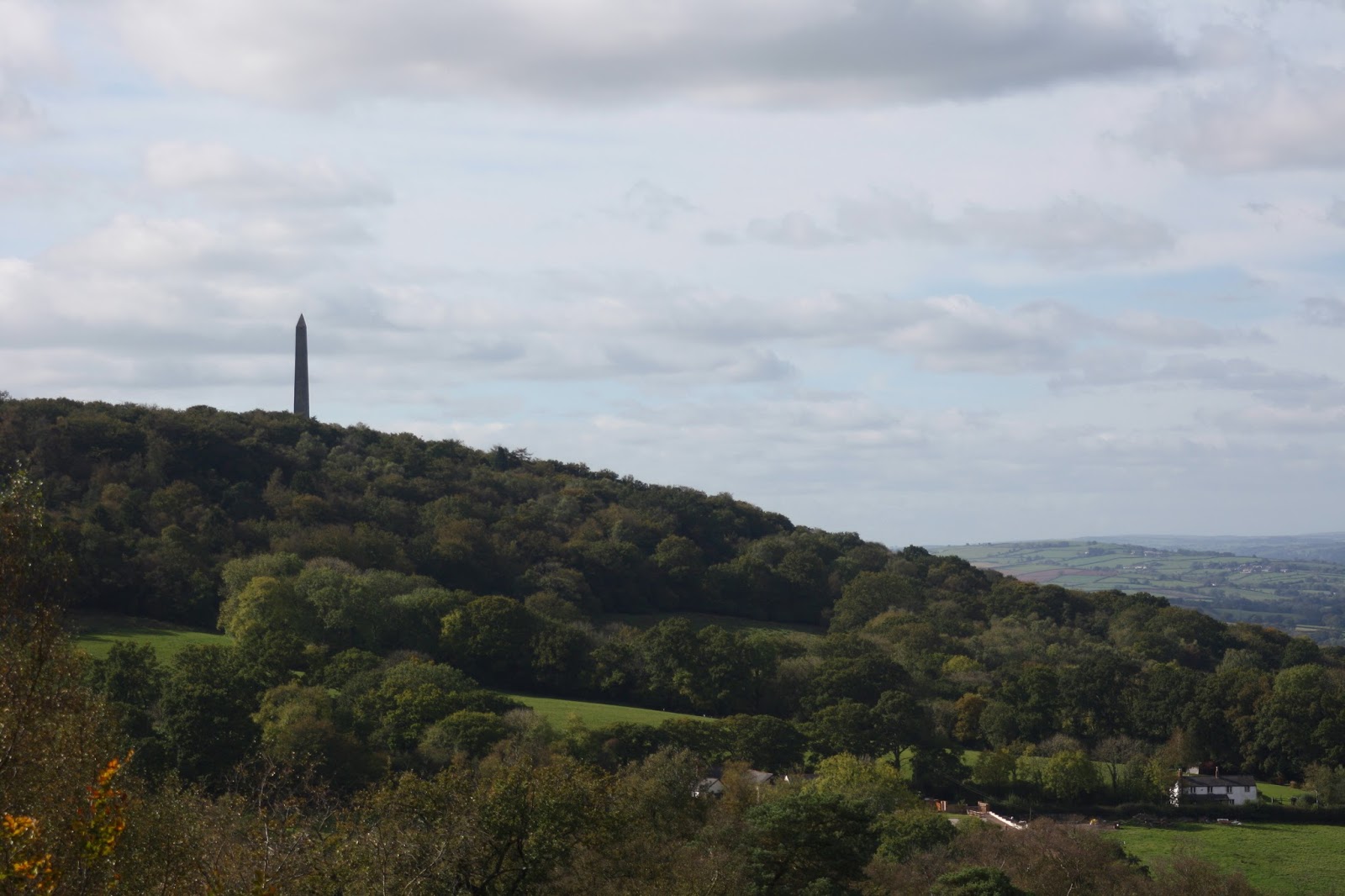
The Wellington Monument on the Blackdown Hills in Somerset. A striking tribute sorely in need of repair.


The Wellington Monument on the Blackdown Hills in Somerset must be one of the most well-known, if not the most well-known, landmarks visible from the M5 south of Bristol.  Over the years millions of people must have viewed it as they travelled through the Vale of Taunton Deane.  Therefore, it is disappointing that the Heritage Lottery Fund has turned down an application for a contribution to the sorely needed funds required to carry out repairs to this striking monument.* 
The Wellington Monument on the Blackdown Hills in Somerset.

A National Trust information board at the monument explains why the repairs are needed.  It states: “A combination of its exposed position, unique shape, varying quality of construction and failed repairs has contributed to the current poor state it is in”.
A section of stonewall halfway up the Wellington Monument.  Apparently there are voids in the rubble filled walls which presumably exacerbate the problems caused by the ingress of rainwater. 

Erected in honour of The Duke of Wellington, the victor at Waterloo, the monument has a chequered history.  Suggested in 1815, it was not completed to its present height of 174ft until 1892 due to intermittent funding and the need for repairs following a lightning strike in 1846.  It was originally planned to have a statue of the Duke of Wellington at the top of the triangular column with 24 cannons and granite lions at its base.  There was also a proposal for three homes for Waterloo veterans, who would act as caretakers, to be built within the monument’s base.  No statue, veterans’ cottages or lions were forthcoming and although 4 cannons were installed in 1910 they were removed in 1940.  Today there is only 1 cannon on site, it was installed in 1984.

The National Trust took over the monument, and twelve and a half acres of surrounding land, in 1933.  By 1966 another sixty-two acres were in the care of the Trust.  From the spacious car park it is a pleasant, level walk through an avenue of trees to the monument where you can glimpse views over the Vale of Taunton Deane with the Quantocks, Brendons and Exmoor beyond. 

  
*Here is a link to an explanatory article on the ITV News Website.

Friday, 31 March 2017

Willett Tower, a folly near Elworthy, in Somerset's Brendon Hills.


Willett Tower, near Elworthy, in Somerset’s Brendon Hills is within the Forestry Commission’s Willett Hill Plantation.  The entrance to the plantation is on the B3224 just 4.9 miles west of the junction with the A358.  On the last day of March, I found it a very pleasant drive along a gently twisting and undulating road with primroses on the banks and one suicidal pheasant which I managed to safely avoid!
Willett Tower, near Elworthy, in Somerset's Brendon Hills.

There is a small parking area at the plantation entrance which gives access to a steady but steepening climb up the 825 feet high Willett Hill to the Tower.  As you climb the track, stop and look back to the east and north-east to enjoy, while catching your breath, the views over the tree tops to the Quantock Ridge.
The ridge of the Quantock Hills viewed from the track leading to Willett Tower. 

The folly tower is meant to represent the ruined tower of a Somerset church.  I have come across several suggestions as to who it was built for, but I will quote Pevsner who states it was:  “. . . a folly tower erected in 1820 (by Mr Belmerton, probably in connection with Willetts, a house further NE)”.

Regrettably, what started off as a sunny day with scattered cloud turned into a grey and slightly drizzly afternoon.   It was not really the best conditions for photography, but at least I got some exercise.       

Saturday, 17 September 2016

Watchet Harbour on the Somerset Coast.


I had never visited Watchet Harbour so, as it was a warm, bright and sunny September day, I set off north along the A358 towards the Somerset Coast to take a look.  On leaving Taunton the road twists and turns up and down past prettily named villages and hamlets such as Combe Florey, Seven Ash and Sampford Brett.  The road was quiet and I was able to enjoy a relatively slow drive without getting in anyone’s way.  I stopped several times before reaching Williton to take in the beauty of the Quantock Hills to the east and the foothills of the Brendon Hills to the west – and savour the peace and quiet.  At Williton I joined the A39 for a short distance until, at the Tropiquaria, turning right onto the B3190 to Watchet.

The town has several convenient pay-and-display car parks; I was able to park just 25 yards from the harbour wall.  I spent a couple of hours wandering along the harbour wall with binoculars and camera.  It was a clear day allowing fine views of both the English and the Welsh side of the Bristol Channel.
A view from Watchet Harbour wall looking east through the harbour entrance across St.Audries Bay to the Quantock Hills. 


The tidal harbour is no longer in use, but it has a long and varied history.  The Saxons arrived in the area in the late seventh century.  By the time of Alfred the Great, Watchet had become an important Anglo-Saxon port.  By the seventeenth century ships were trading throughout the Bristol Channel and the Irish Sea as well as with London and the Continent.  Trade through the harbour reached its zenith in the second half of the nineteenth century with exports of iron ore from the Brendon Hill mines and imports of Welsh coal.

The harbour was badly damaged by a severe storm in December 1900.  It was soon repaired and trade continued during the next century until the port closed to commercial traffic in 1999.  In 2001 the harbour was divided to provide an enclosed marina with capacity for 250 yachts.
Watchet Esplanade, from where the marina can be viewed.


On leaving the harbour wall I strolled along the picturesque Market Street, with its museum, as far as Watchet Esplanade which overlooks the marina.  Then, with the parking meter in mind, it was time to go back to the car and head west up the narrow streets of Watchet and make for Blue Anchor along the B3191 – but that’s another blogpost.

For more detail on the history of Watchet Harbour and mining iron ore on the Brendon Hills, these links are of great interest:

http://www.westsomersetmineralrailway.org.uk/welcome/a-short-history/mining/

Saturday, 28 November 2015

Clatworthy Reservoir in the Brendon Hills, West Somerset.

One weekday last August I decided to pay a first visit to Clatworthy Reservoir, the smaller of the two reservoirs in the Brendon Hills.

Clatworthy is reasonably well signposted from Wiveliscombe so I followed the country lanes via Langley Marsh, Maundown and the prettily named Huish Champflower: Huish is a Saxon word meaning lands or household while Champflower is the name of the family which owned the lands in the 12th century.  It was a slow but enjoyable drive, twisting up and down hills through, in places, very narrow lanes.  When I arrived just after midday at the spacious free car park, which is on a hill overlooking the dam, it was very peaceful with only a handful of cars dotted around.

The reservoir, run by Wessex Water, takes its inflow from the River Tone and is 130 acres in area with a capacity of 5,364 million litres.  It was inaugurated by H.R.H. Princess Alexandra of Kent on the 6th July 1961.  The settlement of Syndercombe, mentioned in the Domesday Book, was flooded on the creation of the reservoir.
Clatworthy Reservoir viewed from the car park. 
For walkers - no dogs allowed - there is a footpath around the 5 mile perimeter of the reservoir.  I decided to walk down the hill and cross the dam to the wooded hill on the far side.  Unfortunately, as an asthmatic, this was a bad choice as by the time I had negotiated the zigzag path up the hill I was too worn out to go further.  Next time I visit I will try the clockwise route as it appears to follow more level ground although I don't envisage walking the whole circuit: the hills seem to be a bit too demanding.
The fish farm with its trout ponds below the dam.